Looking to do something active while visiting the Costa Brava? Hiking might just be the thing if you get tired of the beach.
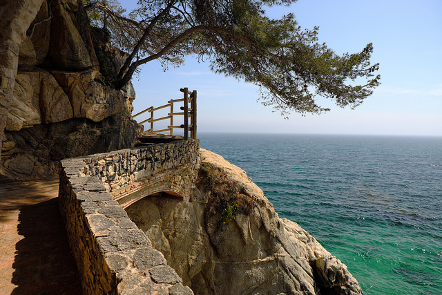
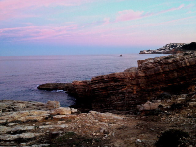
Breathtaking sea views from the camí de ronda. Photo by L’Oriol.
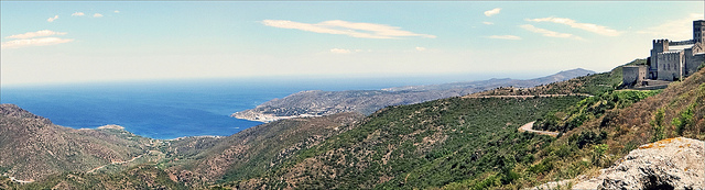
One of the great things about the Costa Brava is its beauty, with many areas remaining completely unspoilt. And one way to really get up close and appreciate it is on your own two feet. Out in the fresh air with plenty of fantastic views. All you need is an idea of where you’re headed, decent shoes or walking boots, suitable clothing and water.
You’ll probably want your camera too.
Along the way you’ll come across picturesque fishing villages, pine-topped cliffs and areas of outstanding natural beauty.

First we’ll look at the camí de ronda, the coastal path that runs pretty much the entire length of the Costa Brava, including some of my favourites. After that we’ll move on to some other walks inland where you can explore hiking trails that crisscross the hills.
If you have any questions, tips or suggestions then please leave a comment.
Or you might like to check out this book of Costa Brava walks if you prefer to carry a paper map with you while hiking.
The camí de ronda
If you want to stick to the coast then the camí de ronda runs all the way from Blanes up the Costa Brava to Portbou on the border with France.
The camí de ronda consists of more than 200 km of coastal paths that date back to the nineteenth century, originally used to watch out for smugglers. The Guardia Civil used the paths as recently as the Franco dictatorship when things such as food, tools and cigarettes were in short supply following the civil war.
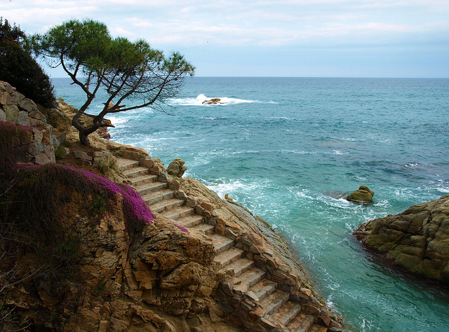
A section of the camí de ronda between Port de la Selva and Llançà. Photo by David Leigh.
After the 1950s these paths came into disuse. As a result some sections became overgrown and remain impassable. On the other hand other areas have been well tended. Sometimes you’ll walk on paving, sometimes you’ll have a handrail and illumination.
But while nowhere as rough as they once were, these winding coastal paths often change elevation and are extremely narrow in places – not recommended if you don’t have a head for heights. There are clifftop sections and sections across beaches, stone steps and little more than dirt tracks.
Although you can certainly spent ten days to a fortnight walking the entire Costa Brava coast, most people are only ever going to walk shorter stretches.
The coastal path in L’Escala. Photo by David Leigh.
Generally the paths are well marked so you shouldn’t have too many issues finding your way, however long or short your planning walk. On the whole the route is well marked but it does make sense to carry a smartphone with Google Maps, a GPS – or simply a map!
Don’t rely on Google Maps entirely as it doesn’t include much of the camí de ronda. Do use the app if you get lost though. Unlikely, but not impossible!
But also remember that following the paths along winding cliffs means the walk can easily be twice as long as taking a more direct route.
Costa Brava hiking tours
If you’re staying in Barcelona and plan on spending a day hiking then a good option is to book a guided walking tour.
You’ll directly experience the beauty of the Costa Brava on a 5 hour hike and you can walk at a pace that suits you. Includes hotel transfers.
Sant Feliu de Guíxols to Begur
One popular route along the camí de ronda is a two or three day hike from Sant Feliu de Guíxols to Begur. Done over three days the 43 km route consists of the following stages:
- Sant Feliu to Palamós (17 km) via S’Agarò and Sant Antoni de Calonge.
- Palamós to Llafranc (13 km) via Cap Roig and Calella de Palafrugell.
- Llafranc to Begur (13km) via Sant Sebastià lighthouse.

Calella de Palafrugell. Photo by Joaquin Aranoa (Pixabay).
For me the section along the seafronts of both Platja d’Aro and from Sant Antoni to Palamós aren’t particulaly interesting though. Although the section between Sant Pol and Sa Conca is spectacular (see below), if you want a longer walk you’re better of sticking to the section from Llafranc to Begur. It’s one of the best bits of coast on the entire Costa Brava, all rugged cliffs and pine trees above the sea.
That said, let’s move on to my favourite walks along Costa Brava.
Platja Sant Pol to Sa Conca
After leaving Sant Feliu you’ll get to the beach at Sant Pol. Here you’ll see a number of Catalan modernist houses and a long beach that reaches S’Agarò, a luxury devopment dating from the early 20th century.
The camí de ronda at S’Agarò. Photo by Queralt Boix.
This route is relatively easy, although you do need a head for heights. Here you can admire the large gardens belonging to the mansions overlooking the Mediterranean or just enjoy the views.
Along the way you get plenty of sheer drops, but the path is well made and there are handrails along the entire route. If you suffer from heights though you may find it difficult. You can start walking and if it gets too much there are a number of places where you can abandon the coastal path for straight asphalt road.
If you walk this winding path and then take the direct route back you’ll be amazed at the difference in time. As the crow flies you actually don’t actually travel very far at all, but the route certainly makes you feel you’ve walked some kind of distance.
Note: in the map above the walk is split into two sections that meet at the mirador. For some reason Google Maps doesn’t recognise that this makes a continuous path.
If you want a more serious walk then you can continue around the marina at Platja d’Aro and continue along the long sand beach until you once again reach rocky terrain. Continue along here to reach Sant Antoni de Calonge and then you can continue towards Palmós. The town is famous for its prawns so well worth it if you have the time and energy.
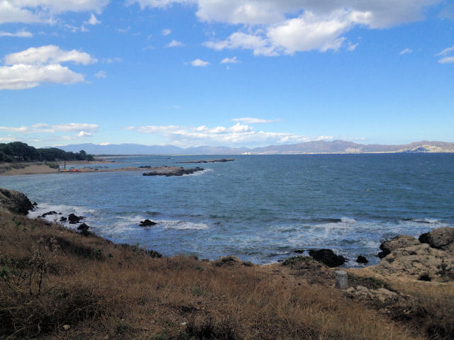
Former military zone in L’Escala
Until relatively recently area between the L’Escala’s marina and Montgò was a military base. Today it is a protected area where it’s great to walk your dog off season.
The former military zone in L’Escala in December. Photo by David Leigh.
The zone was used by the military until perhaps the late 1990s, although I don’t remember exactly when it closed and can’t find that information online. It now forms part of the natural park that encompasses the Medes islands after the local council bought the land from the Spanish defence ministry to prevent it from being developed.
There are a number of bunkers that were used to house artillery, which were starting to deteriorate thanks to neglect and vandalism. However the council has stepped in to preserve these as part of the town’s history.
Much of the path is above the cliffs and can get a bit blowy in winter but the path does go down to a very rocky beach. It’s not far, but good enough to stretch your legs. A much longer walk will take you over the top of the Montgrí massif to Estartit.
L’Escala to Sant Martí d’Empúries
To the north of L’Escala lies the Greco-Roman ruins of Empúries and the remains of the Greek harbour before arriving at Sant Martí.
The paths there are quite easy and mainly wide asphalt. You can vary that by walking on the sand of various beaches along this stretch of coast until you reach Sant Martí d’Empúries. A good place to stop for lunch!
The Greek harbour at Empúries. Photo by David Leigh.
We like to walk our dog along here off season so she can have a run on the sand, but any time of the year is at least part shaded by the pines. Between the beaches and the asphalt are protected dunes and you get a pretty good view of the Greco-Roman ruins through the chain-link fence. You do at least get an idea of the scale of the site.
After Sant Martí you can continue to the long sand beach that runs all the way to Sant Pere Pescador. This beach is well known for its windy conditions and a popular spot of wind surfers and kite surfing.
El Port de la Selva to Llançà
The path between El Port de la Selva and Llançà has been improved dramatically over the last decade or so.
While it was all fairly basic when I first walked to Llançà, the sections that are now paved are flat and wider than they used to be. They’ve gone a bit too far in my opinion, but I don’t make the decisions. I love this while area and you get some truly breathtaking views along the way.
The path is still sometimes narrow with a fair drop to the rocks below, so be aware of that if it’s an issue. But there are some lovely coves along the way to have a dip. Halfway between the two towns you’ll come to the peninsula with Sarnella lighthouse and the path crosses at least one pebble beach close to the Port de la Vall campsite.
It’s around 6 km in total and relatively straightforward. If you time things right you can take the bus back from Llançà to Port de la Selva too and save yourself the return walk.
One of my favourite memories of this walk is coming across a fruit shop where I bought what must have been the juiciest nectarine ever! The map shows the route from the car park near Hostal L’Arola to the beach of Cau del Llop on the outskirts of Llançà.
El Port de la Selva to Cala Tavallera
I don’t think this walk is officially part of the camí de ronda but it’s a 7 km walk with a deserted hermitage along the way and a beach at the end.
The scenery here is pretty stark, lots of rock, low scrub and pine and for most of the time you’re not close to the sea at all, although you get glimpses of it before you arrive on the beach. The hermitage, Sant Baldiri de Tavallera, is in reasonable condition still and worth stopping for a few minutes. But the map above shows a non-existent restaurant. When you check the address it is in Cádiz in the very south of Spain! There is a farmhouse there though.
I once did this on a blisteringly hot day and we didn’t take enough to drink. Once we arrived at Cala Tavallera the freshwater well we were counting on wasn’t usable either. And the beach, which we were expecting to be deserted, was full of people with their boats moored offshore!
We swam then started the trudge back after drying off. And when we were almost back in Port de la Selva, looking forward to buying 8 litres of water to tip down our throats, we came across a mountain biker who had come off his bike. We drove him to his uncle’s house with a broken shoulder and just made the supermarket before it closed.
Hiking inland
Just because you’re on the Costa Brava doesn’t mean you need to stick to the coastal paths though. With much mountainous terrain and plenty of forest you can imagine there are lots of trails to follow.
These include both official paths, which are clearly marked, simple forest paths, or mountain roads. Let’s look at some of them.
El Port de la Selva to Sant Pere de Rodes
Want to feel on top of the world? You’ll feel exactly that when you do this walk but it’s a fairly tough one.
Sant Pere de Rodes and the view over the bay. Photo by Jean-Pierre Dalbéra.
Starting at sea level in Port de la Selva you climb a winding mountain road up to the monastery of Sant Pere de Rodes at an altitude of 500 metres. From there you can climb even higher, to the Castell de Verdera, at 590 metres. But the view is spectacular, looking out over the bay towards France, over Cap de Creus and the Bay of Roses and inland towards Figueres.
The monastery has been restored and worthwhile exploring and you get a basic, but good a cheap lunch in the restaurant there. It’s a 7.5 kilometre walk uphill, but at least the return leg is assisted by gravity.
Ruta de les ermites
From the spa town of Caldes de Malavella you can follow circular 30 km ruta de les ermites through farmland and forest that takes you to five hermitages, churches and chapels.
- Sant Maurici
- Sant Sebastià
- Sant Mateu de Franciac
- Sant Andreu Salou
- Santa Ceclina
The now-abandoned church of Santa Seclina. Photo by David Leigh.
The walk is long but relatively flat, although there is a moderate climb up to Santa Seclina. At various points it intersects with other routes that allow you to return to your start without completing the entire route.
If you don’t feel like completing the entire walk in one day then consider doing it over two days. If you have a car you can simply walk from one church to the next and then return to your starting point.
Cap de Creus
The Cap de Creus is protected as a natural park with a variety of different walks.

The stark landscape of Cap de Creus. Photo by Marc Pascual (Pixabay).
For example, starting in Cadaqués you could walk to nearby Portlligat, where Salvador Dalí had a home. From there you can walk through the rocky paths to the Cap de Creus lighthouse. Rather handily there is also a restaurant.
From the lighthouse you retrace your steps until you reach the turnoff for El Port de la Selva via Cala Tavallera. After a refreshing dip in the sea you continue to Port de la Selva for more refreshment. If you’re not going to stay overnight you can either walk back to Cadaqúes, a total circuit of some 37 km. Or you can take it easy and take the bus back.
That’s not the only walk in Cap de Creus though and there are plenty of small beaches and coves to explore.
The greenways
If you want to take things easy then you can always walk the vies verdes or “greenways”. Following the routes of the old narrow gauge railways, the greenways are relatively flat paths exclusively for walking and cycling.

Hiking after some serious rainfall. Photo by David Leigh.
You can walk all the way from Girona to Sant Feliu de Guíxols without having to worry about road traffic for most of the way. The paths are quite flat and so make for a pretty straightforward hike despite weaving through the hills between Llagostera and the coast. At 40 km you may want to complete the walk over a couple of days though.
There is another 6 km greenway between Palamós and Palafrugell, which is far more manageable. And running westwards from Girona is a 57 km route that goes all the way to Olot.
More hiking trails
It’s impossible to cover ever single hike on the Costa Brava in an article such as this. I can only give you a flavour of the routes and some ideas based on my experience of living here.
But anywhere with forest will have paths you can follow. If you’re driving in any of these areas and see a signpost marking a path you can park you car and get walking. Who knows what you’ll find?
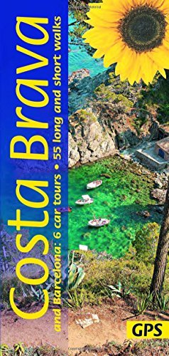 If you prefer to rely on a low-tech solution to plan your hikes and help you to navigate then consider investing in a copy of Costa Brava and Barcelona: 6 Car Tours, 55 Long and Short Walks.
It’s available for a small amount from Amazon ES, Amazon UK and Amazon.com and includes a total of 55 long and short walks with maps and downloadable GPS routes. On top of that it includes six car tours with driving maps, plus timetables for public transport.
We earn a small commission for every book sold, which helps toward the running of this site.
Click the links below to order online:
If you didn’t find what you’re looking for then please let me know!
Leave a comment below and I’ll do my best to answer you ASAP.
5 Comments
Hi! I’ve been living in Barcelona for the summer and am planning a day trip to Costa Brava for later this week with my girlfriend (probably Thursday or Friday when I can take a day off work). We’re trying to find the most scenic stretch of hiking along la Cami de Ronda to do, hoping for something that doesn’t stray too far inland/is consistently close to the coast. We’d also love some variety in the hike to get the full effect — perhaps some portions up along clifftops overlooking the ocean, other parts walking across sandy beaches, etc. (We’re both pretty capable hikers.) The two stretches that loom like our best options are something between Sant Feliu and Palamos, or between Llafranc and Begur. Any more details on those two stretches or a recommendation between the two? My only concern is finding public transit to get to a good starting point and then being done early enough to find a train or bus back to Barcelona (any advice on that would be appreciated too!). Left my email for a response…let me know what you would suggest! Thanks so much, really excited to explore this beautiful coast!
I think I’d really recommend Llafranc to Begur but it’ll be difficult on public transport. Sant Feliu to Palamós is probably easier from the public transport point of view.
Another option to consider is taking the train up to Portbou and walking along the coast down to Llançà where you can get the train back to Barcelona. The coastline up there is amazing and there are fewer people than further south.
Hello! Me an my friend are going to Barcelona and want to do 2-3 day hike in Costa Brava. We want to hike to a different village and stay for 2 different nights. I need to book them soon and am not sure what is best. We are both fit and want to see great views.
Any suggestion is great appreciated! Or if there is a company I need to book through.
Thank you!
Difficult to make a recommendation off the info you’ve provided. Maybe take the train from Barcelona to Portbou and walk back to Llançà, Port de la Selva, Cadaqués and Roses. You’ll get some great views and some of the quieter stretches of the Costa Brava (until Roses).
hi
are there any moderate to challenging summits to trek of upto 3-4000m?
any treks easy to moderate?
if so are they clearly marked and safe to trek solo?